
According to an assessment report by the authority, the floods in the Trishuli River are estimated to cause a loss of around 7,700 tons of food grain production. For farming families, this means not only the loss of the current crop but serves as a warning that future production and income opportunities could also be thrown into crisis.
Sita Thapa Magar of Paharebesi in Uttargaya Rural Municipality-4, Rasuwa, had gone to her fields early in the morning on August 26 after finishing her household chores to weed her crop. After weeding and fertilizing the paddy that was about to flower, she had planned with her sister-in-law to go pick sal leaves. But now, neither her sister-in-law remains, nor her fields, nor the paddy. 
The flood on August 26 turned her fields into a desolate gravel bed. She says, “The field where I had been weeding paddy all morning turned into a bleak expanse covered in mounds of debris in a matter of moments.” The raging floodwaters of the Trishuli River, which reached right up to her home and shed, swept away her house and livestock along with her fields.
Sita’s family owned six ropanis of land. They had received four ropanis as their ancestral inheritance and earned an additional two ropanis through a lifetime of hard work. This land fed a family of five. Now, there are no fields there, only debris and gravel can be seen.
Having lost her home in the 2015 earthquake, she had built a new house using grant money. Back then, even though her house collapsed, her crops and livestock were spared. But this time, nothing is left.
“In the shed, there were two buffaloes due to give birth the next day on August 27, two calves and 15 goats,” Sita recalls. “The granary was full of paddy, corn, wheat and millet. We had no worry about what to eat. Now, everything has been turned to sand.”
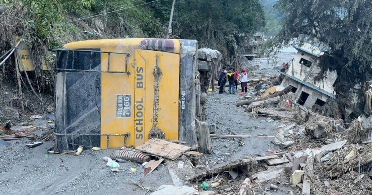
This is not Sita’s plight alone. This has become the fate of every resident along the banks of the Trishuli River across Rasuwa, Nuwakot, Dhading and Gorkha, affected by the flood caused by an avalanche of ice and rock north of Langtang Lirung mountain in Rasuwa. Glacier and glacial lake researcher Nitesh Khadka explains that the debris-laden flood was triggered by the melting of ice and water generated by the friction of falling glacier ice and rocks.
According to the Rapid Damage and Needs Assessment Report released by the National Disaster Risk Reduction and Management Authority, the floods caused total damages and losses exceeding Rs. 408.28 billion across all sectors. The study states that Rs. 723.31 billion will be required for reconstruction and rehabilitation.
In this flood, thousands of families like Sita’s simultaneously suffered the loss of their homes, crops and livestock. Sita lost two buffaloes, two calves and 15 goats, livestock that serve as a primary source of cash income for rural farmers.
According to the assessment report, 252,445 head of livestock and poultry were lost in the flood, resulting in an economic loss of Rs. 1.44 billion. A total of Rs. 1.73 billion is required for the recovery of the livestock and poultry sector.
The report highlights that 1,806 hectares of productive land were damaged by the flood, with Bidur Municipality in Nuwakot alone accounting for 798 hectares. According to the authority’s report, a total of Rs. 1.42 billion will be required for the revitalization of the agricultural sector.
The floods destroyed not only individual farmers’ property but also state-owned agricultural assets and farms. The floodwaters swept away the Fishery Research Center and the Horticulture Development Center located along the banks of the Trishuli River. According to the authority’s assessment, damages to the fisheries sector stood at Rs. 715.9 million, with recovery estimated to cost Rs. 1.07 billion.
Similarly, 197 ropanis of land belonging to the Horticulture Development Center, under the Bagmati Provincial Government, was turned into a gravel bed, according to Information Officer Thakur Prasad Neupane. Mother plants of lychee and various varieties of mango trees located on that land were destroyed. The center served as a national resource hub for avocado, distributing saplings across the country.
The authority’s assessment report notes that the Trishuli floods will lead to a production loss of approximately 7,700 tons of food grains. For farming families, this is not merely an immediate loss of current crops. It threatens their future production and long-term earning potential.
Former National Planning Commission member and Associate Professor at Tribhuvan University’s Central Department of Economics, Dr. Ramesh Paudel, stated that the floods are estimated to have caused an overall loss equivalent to 10% of the Gross Domestic Product (GDP). He adds that although the numerical share of damages to crops and livestock appears small (0.93%), its impact is incomparable because it directly affects the daily lives and livelihoods of farmers.
According to Dr. Ramesh, the floods destroyed farmers’ houses, lands, fields and threshing floors. Returning to the previous state will require massive expenditure and immense effort. In many instances, no matter how much effort and investment are put in, it is impossible to restore conditions to what they were before.
He notes that these floods have shattered the very ecosystem of the farmers. “There are no fertile fields left to cultivate and those whose fields survived cannot access markets,” Dr. Ramesh adds with examples. “Vegetable vendors cannot sell vegetables, fruit vendors are unable to sell fruits, and produce is rotting away in the fields.”
The example he gives matches the current situation of farmers in Aamachhodingmo Rural Municipality of Rasuwa exactly. According to Dawa Gombo Tamang, spokesperson for the rural municipality, vegetables worth Rs. 70 million belonging to farmers across Wards 2, 3, 4, and 5 are rotting in the fields.
Because rice yield is poor in this village, farmers earned Rs. 40 million last year from vegetables like potatoes, cauliflower, cabbage and beans, prompting them to expand cultivation this year. Spokesperson Dawa explained that while farmers used to buy daily necessities like rice by selling their produce in Trishuli and Kathmandu, the severance of the road network by floods has left vegetables rotting in the fields and created a shortage of daily consumables in the village.
Dr. Ramesh explains that because the floods destroyed bridges and road networks, agricultural produce from areas spared by the disaster cannot be brought to the market. “Trade and businesses have sunk and been completely ruined, hotels have been destroyed,” he says. “The livelihoods of farmers who depended on river basin areas have been lost.”
Riverfront civilization based on agriculture
Riverbanks are the foundation of human civilization. Because land along riverbanks is fertile and offers easy access to water, it holds vast agricultural potential. Consequently, human settlements began to settle in these areas. Anthropologist Suresh Dhakal explains that world civilizations developed in precisely this manner.
Although human civilization originated along riverbanks, settlements were not initially built right next to the water. In earlier times, settlements were situated slightly higher up, while farming was carried out in the flat valley plains below. However, he notes that this practice gradually changed over time.
Also read: Flood-Swept Schools Struggle to Find Space to Reopen
Traditional systems of livelihood and settlements gradually vanished. Roads were built following the riverbanks and settlements began to spring up along those roads. As a result, riverbanks transformed into market areas and land prices soared. People started settling with an eye toward immediate profits rather than long-term sustainability. Anthropologist Dhakal noted that these settlements emerged due to transportation access, which is precisely what happened in Nuwakot.
According to him, two types of livelihoods emerged along the banks of the Trishuli and Bhote Koshi rivers: agriculture-based and trade-focused. After the opening of the Rasuwagadhi border point, trade-centered market areas grew all the way from Galchhi in Dhading up to Rasuwagadhi. However, the floods have destroyed both forms of livelihood.

Citing examples of major world civilizations disappearing due to disasters, anthropologist Suresh says, “The Indus Valley Civilization we often hear about is one of them.” In the aftermath of a major disaster, civilizations cannot be restored to their original form. Explaining that it is difficult to restore the cultural preservation and historical significance of such places, he notes that the foundation for a new, advanced civilization can instead be laid there.
However, he contends that attention must be paid to historical continuity and cultural significance during restoration. According to him, history saved from the flood can be preserved through physical structures by creating new inscriptions. This is essential to ensure the continuity of this knowledge for generations to come in the future. What people hear orally can be forgotten after some time but physical artifacts serve as a reminder across generations.
What is the way forward now?
When reaching Bogatitar in Rasuwa on September 7, Sita was observing the customary mourning period for her sister-in-law, who went missing in the floods. Having completed the 12th-day post-death rituals at her brother-in-law’s house that evening, they were preparing to move to a holding center at Shivalaya Basic School to stay.
All five members of her own family are safe, which is their single greatest relief at present. However, their daily routine has changed completely. There are no fields left to farm in the morning and evening, nor any livestock left to feed with grass and there is no firewood too. “Our only wealth was our fields, our livestock and our harvested crops,” she says. “Now, all those assets have vanished beneath the debris.”
Families like Sita’s who have lost everything in the floods are standing at a decisive crossroads, a tipping point. On one hand, if aid arrives in time, spring shoots of life may sprout once again. On the other hand, if assistance is delayed, this loss could transform from a temporary crisis into permanent displacement, from which there is no turning back.
Not just the settlement, life too must be restored
Sita is currently searching for both a safe home and a way to earn a living. Like her, other farmers also wish to return to their routine from before the floods. In places swept away by the flood, the immediate concern is having a roof over one’s head, which is entirely natural. However, anthropologist Suresh Dhakal argues that in times of disaster, one must look beyond merely providing temporary shelter.
“We forget the long-term perspective,” he says. “In society, there is a system of mutual exchange, sharing and reciprocal labor. That is social capital. Similarly, there is cultural capital, including language, customs and a shared lifestyle.”
He contends that rehabilitation built while ignoring social and cultural capital will not be sustainable. “Post-earthquake rehabilitation was not viable in the long run because attention was focused solely on building houses,” Suresh says.
According to him, rehabilitation planning must address economic, social and cultural dimensions within a single integrated package. This requires involving social researchers alongside engineers, while ensuring citizens’ rights are given due consideration. Rehabilitation must cover not just housing but livelihoods as well.
Economist Dr. Ramesh agrees with this view, emphasizing the development of integrated settlements. “Floods, landslides and flash floods recur frequently. Settlements located in high-risk zones, where the state cannot reach within 10 to 15 minutes, or where the cost of access exceeds the livelihoods generated there, should be progressively consolidated into integrated settlements,” he says. “Reorganizing settlements is an appropriate option but it must be carried out only after working out cost structures and livelihood mechanisms.”
According to Dr. Ramesh, creating such a plan is far from easy. The first question that arises is what will sustain people’s livelihoods in a new location? It must be determined whether those affected wish to pursue farming, seek employment or run businesses in the area. Calculations must also account for how long it takes to reach these locations on foot or by vehicle, as well as where hospitals and ambulances can be found in the event of illness.
If agriculture remains the foundation, the question of where to allocate land becomes even more difficult. He notes that establishing a settlement while providing farmland that takes hours of walking to reach makes no sense, as land holds value only when it is located close to the settlement. “Some had large landholdings but it won’t be possible to grant the same amount elsewhere now,” Dr. Ramesh says. “There is also the question of how a family will sustain itself on a smaller plot of land.” He suggests that local governments must carefully plan whether to direct the surviving workforce toward the hospitality business or agriculture.
Also read: The River Came at Nine
Authority Spokesperson Shanti Mahat states that plans are underway to relocate flood victims away from high-risk zones and areas unsafe for farming, and to develop integrated settlements complete with land allocations.
Agricultural recovery remains a massive challenge. According to anthropologist Suresh and Associate Professor Dr. Ramesh, this is not a task that can be accomplished simply by replacing seeds. It is essential to first identify which fields can be brought back into production, restore topsoil where necessary, repair drainage and irrigation systems, and support farmers so they can prepare for the next cropping season.
According to the authority’s report, the floods damaged 798 hectares of arable land in Nuwakot’s Bidur Municipality alone. Madan Raj Neupane, head of the agriculture branch at Bidur Municipality, reported that sand and massive boulders have piled up across 65% of the damaged river plains. He notes that these plains can be rendered arable once again using excavators and bulldozers.
He added that alongside ongoing data collection, discussions are taking place among stakeholder groups regarding land reclamation. Preparations are being made to reclaim agricultural land with the active involvement of farmers, demarcate plots and return them to farming by the next season.
Also read: Mud Everywhere, Bodies Left Uncollected, and Rescue Without a Rope
Nabin BC from the Agriculture Branch informed that Uttargaya Rural Municipality in Rasuwa is also collecting data on damages caused by the floods to the agriculture and livestock sectors.
He stated that the rural municipality is currently conducting a sector-specific needs analysis for the recovery of affected areas to work through an integrated plan. He added that although the municipality had insured the farmers’ livestock, a concrete decision regarding the claim payouts to be provided to the farmers has not yet been made.
Cover photo: The bank of the Trishuli River in Nuwakot turned into a gravel bed by floods. Photo: Rajneesh Bhandari/NIMJN.
Please adhere to our republishing policy if you'd like to republish this story. You can find the guidelines here.

Comments