Read this story in Nepali: कञ्चनजङ्घा क्षेत्रमा बढ्दो बाढीपहिरो
Lonak, the final village before the Kanchenjunga base camp, serves as the ultimate refuge for trekkers embarking on the Kanchenjunga expedition. Given that the base camp, situated at an elevation of 4,790 meters, is a day's trek from Lonak, allowing for a same-day return, the village hosts hotels catering to tourists. However, a pervasive sense of uncertainty and impending crisis hangs over the local hoteliers. They face the grim reality that they cannot predict how long this scenic village will endure or how much longer they will be able to sustain their businesses there.
 Tenjing Sherap Sherpa, a hotelier, has personally witnessed the dramatic shifts in the village's landscape and harbors deep concerns that Lonak's very existence may one day be jeopardized.
The United Nations Intergovernmental Panel on Climate Change in its 2023 Synthesis Report has said that human activities, principally through emissions of greenhouse gases, have caused global warming, with global surface temperature rising. Rising temperature of earth has caused topographical changes in the Himalayan region and Kanchenjunga, which spreads across 2,035 square kilometers, is no exception.
The trekking route to the base camp is frequently impacted by landslides and the emergence of new glacial lakes.
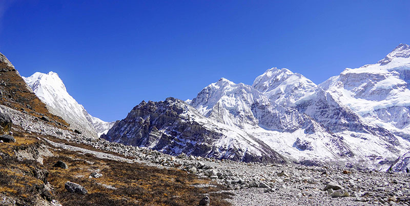
Kanchenjunga is an example of change. The glacial lake at Lonak (see cover photo).
This lake appears to expand annually. Locals report that the lake now occupies a site where cowsheds once stood. "We haven't named this lake, but it's getting bigger every year," Tenjing explained. "About 10 to 15 years ago, there were cowsheds here. The grazing land has become a glacier, and where the cattle used to roam, there's now a lake."
Tenjing Nupu, another local, has observed a similar phenomenon. Two years ago, when he trekked the Anidesh summit, there was no lake along the route; now, there is one. The water from this lake flows down to Ghunsa and Handrung before reaching the Tamor River. Locals fear that if the lake bursts, it would cause significant loss and damage to downstream settlements, including Khabachen, Ghunsa, and Handrung.
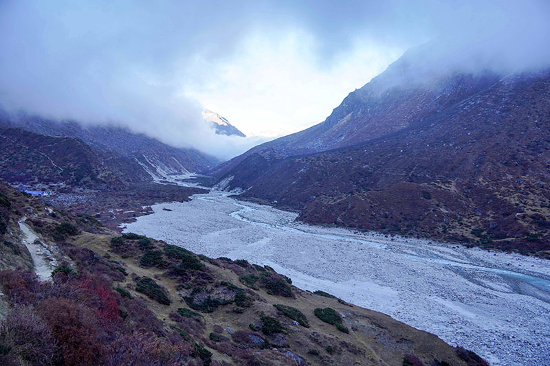
The widespread landslides serve as another indicator of the environmental shifts occurring in the Kanchenjunga region.
Bibek Basnet, information officer at the District Police Office in Taplejung district, reported that Tika Bahadur Rai of Yabu, Sankhuwasabha, a tourist guide, died in a landslide in Itahari on October 5, 2024.
The Kanchenjunga trekking route begins in Japantar and passes through Itahari. Landslide risks are present not only in Itahari but also along the entire four-day trek to the base camp. A report by the Kanchenjunga Conservation Area states, "The topographical structure of this area is too steep. So the landslide risks become too acute during monsoon."
The area bordering northeast India and China from Taplejung district was designated a conservation area in 1997. This region encompasses mountain peaks, including the world's third-highest peak, Kanchenjunga, four peaks over 8,000 meters, and 17 peaks between 7,000 and 8,000 meters.
Due to the risk of landslides, Dikki Sherpa's "teashop" at Zorque, an hour's walk from the base camp, has been replaced by a tent. She explained, "Landslides keep occurring, later the walking trail might be damaged. It is expensive to build a house here. Which is why we have put up a tent here."
Trekkers heading to Kanchenjunga often stop at Zorque for tea, hot water, and soup before continuing their ascent, which sustains local businesses. According to the Kanchenjunga Conservation Area Management Council, 1,085 foreign tourists visited this area in the fiscal year 2023/24. Despite the business potential and her desire to manage her eatery more effectively, Dikki states that she has been unable to invest further due to the persistent risk of landslides.
The trail from Zorque to the base camp has also suffered landslide damage. Debris and piles of earth scattered along the path serve as stark evidence of the ongoing topographical changes in the Kanchenjunga region.
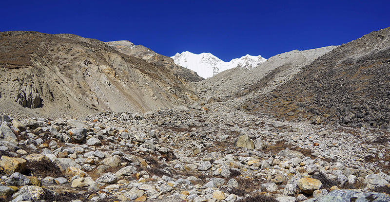
Upon reaching the Panpe basecamp, located at an elevation of 5,142 meters, one is greeted by a direct view of the Himalayas. This base camp, offering views of the pristine white mountains against a blue sky, is also threatened by landslides. While one edge of the base camp is eroding, the other side faces active landslides. The glacier in this area is visibly expanding. Tenjing Nurbu, who operates a 'tea house' at the base camp, is concerned about the future of the magnificent Kanchenjunga mountain.
"There's significantly less snowfall. Melting glaciers may have caused the landslides," Nupu stated. "We've witnessed considerable change in the Himalayan region over the past few years." Like Dikki, Nupu is hesitant to invest further in additional infrastructure for his 'tea house' due to these safety risks.
The changes observed in Kanchenjunga are not isolated to this area. According to Sudip Thakuri, Dean of the Faculty of Science and Technology at Mid-western University, who conducts research and studies in the Himalayan region, numerous changes have been occurring across the Hindu-Kush Himalayan region in recent years. This vast region spans 3,500 km across Afghanistan, Bangladesh, Bhutan, China, India, Myanmar, Nepal, and Pakistan, with Nepal's Himalayas, including Kanchenjunga, falling within it.
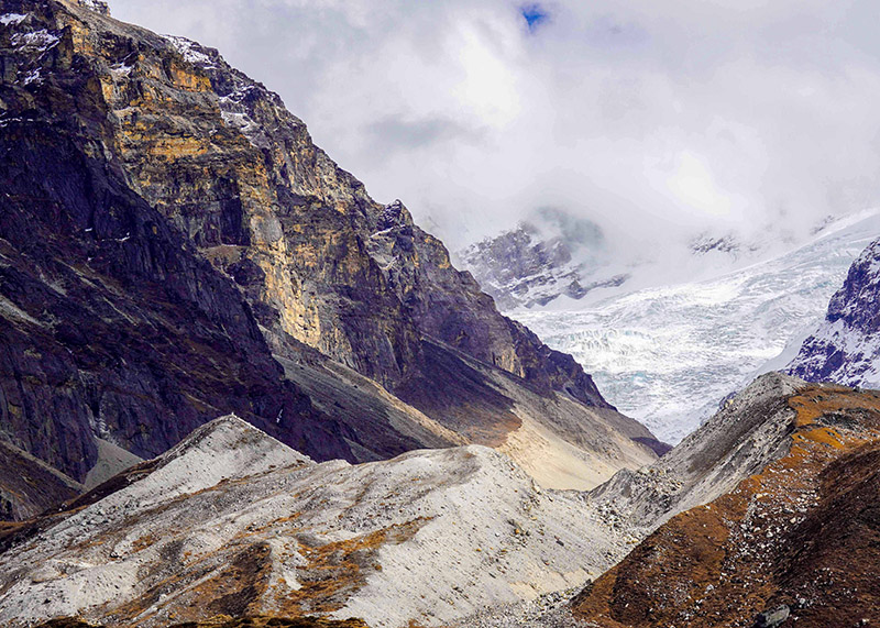
According to Sudip Thakuri, the Kanchenjunga region is particularly susceptible to landslides. He attributes this to the area's proximity to the Tarai, which results in a more compacted landmass, thereby increasing the risks of both floods and landslides.
The rising temperatures and significant decrease in the volume and frequency of snowfall are profoundly impacting the Himalayan region. Sudip Thakuri explains that while land above 5,000 meters typically remains frozen, an increase in temperature weakens the surface, elevating the risks of falling rocks and ice, as well as avalanches.
He stated, "In recent times, incidents such as landslides, avalanches, glacial lake outbursts, melting of glaciers, formation of new glacial lakes, and the expansion of existing glacial lakes have all been observed."
Floods of June and October
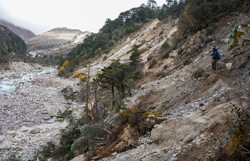
The floods and landslides that occurred from June to October 2024 further exacerbated the fragility of Kanchenjunga’s topography. During this season, tourists found it challenging to navigate the trails due to the widespread flooding and landslides, which extensively damaged the paths in numerous locations.
Some areas have become exceptionally risky and hazardous. "There were dangers in many places. Some sections have become difficult to reach due to the landslides," said Srithulung Rai, who had returned home from Australia and was trekking in the region. "I felt really bad to see floods and landslides making lives difficult in this beautiful place."
Since the shorter trail from Japantar to Itahari was obstructed by landslides, he had to take a longer, more circuitous route. In certain spots, ladders have been installed, and stools placed on narrow sections of the trail to aid passage.
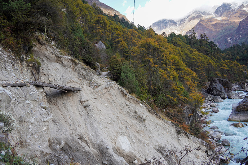
The old route to Lamatar was swept away by the Ghunsa River floods, forcing travelers to take a longer and more arduous path.
Numerous landslides above Ghunsa have rendered the Himalayan region increasingly fragile. The floodwaters have significantly widened the Ghunsa River. Reaching base camp now requires traversing three camps from Ghunsa, a journey that involves navigating through multiple landslide-affected areas—a situation unlike in the past. Paths are obstructed in many places, preventing mules from traveling to Japantar this year.
These changes in Kanchenjunga, Nepal’s second and the world’s third tallest peak, are attributed to the impacts of climate change. However, there are no authoritative or reliable studies and research specifically addressing the floods and landslides and their precise impacts. Given the recurring and damaging nature of landslides and floods in the area, the Kanchenjunga Conservation Area Management Council has formally requested the International Center for Integrated Mountain Development (ICIMOD) to conduct such studies.
It is worth noting that this conservation area operates on a community-based model. Local tourism entrepreneurs and yak herders are responsible for repairing damaged trails. While the Council also undertakes annual path repairs in many areas, these efforts are often hampered by insufficient budget, according to Council officials. Chhawang Sherpa, the Council's treasurer and a business owner in Gyabla along the trail, reports that floods and landslides in Kanchenjunga have occurred with unusual intensity.
According to data from the Department of Meteorology and Hydrology’s Lungthung Center, 375.7 mm of rain fell in September/October 2024, and 631 mm in July of the same year. Locals describe significant floods in even smaller rivulets during these rains, which carried substantial debris into the rivers.
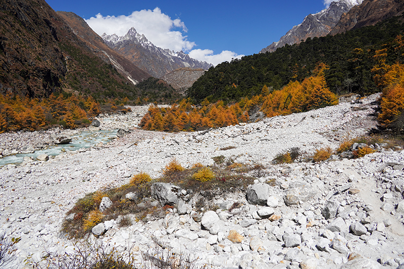
Chhawang reports that landslides have rendered the terrain fragile. He observed, "We've experienced rising temperatures, and significantly less snowfall during the winter season. The paths damaged by floods and landslides in October are still awaiting repair." He added, "I've witnessed numerous changes in my lifetime over the last decade."
Unusual weather patterns
Himalayan cow herders, tourism entrepreneurs, and locals in the Kanchenjunga area are observing unusual weather patterns, including unseasonal snowfall, rising temperatures, and scorching daytime heat. These shifts have, in turn, triggered other environmental changes. "We've lived in this place since childhood and have experienced several changes," remarked Chhawang.
He noted that alder trees, once found only above the Thangyam area, now grow at the lower elevation of the Phale riverbed. Similarly, poisonous snakes, previously absent above Thangyam, are now encountered further up in Gyabla. Sherap, also a ward member of Phatanglung Rural Municipality-6, highlighted the significant losses caused by September snowfall and rain in the lower regions. "It snows when it's not the snowfall season. This year it snowed in September, which caused immense loss and damage," Sherap stated. He added that in Lonak, at 4,780 meters, mornings and evenings are extremely cold, while the days are very hot.
Tenjing Sherpa, another businessperson from Lonak, recounted instances of underground snowmelt triggering landslides in previously unaffected areas. "The ice underground melts and it triggers landslides," he explained. According to Tenjing, glaciers they once crossed on foot have now transformed into lakes. Earlier, they could walk directly to the basecamp, but now landslides force them to take a long, winding path. "There used to be small landslides before. Last year there was a big one," he observed.
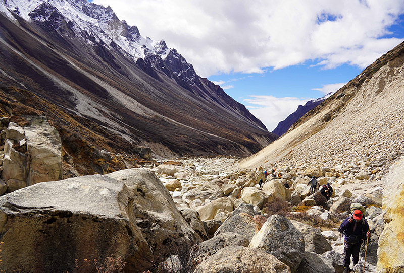
people have to walk upon the rocks. Photo: Giriraj Banskota/NIMJN
Pema Chhiring Sherpa of Khambachen, who observed dry landslides during the daytime in late September, expressed concern about the region's future. He remarked, "Unusual things are happening here. Things that existed are becoming extinct."
Not only locals, but also those engaged in Himalayan research and studies, agree that the changes witnessed in the region are alarming.
Sudip Thakuri, Dean of the Faculty of Science and Technology at Mid-western University, attributes these regional changes to temperature increases induced by climate change. He stated, "Kanchenjunga region is extremely sensitive in the context of climate change. That is the region where rain starts in the monsoon in Nepal. It is very dry in April and May. Once the monsoon starts, the landslides follow."
The past 30 to 40 years show a clear trend of rising temperatures, he noted. Studies indicate that ice in the Kanchenjunga region is melting at a rate of 15%, and landslides occur when rain falls instead of snow.
A study by the International Centre for Integrated Mountain Development (ICIMOD) reveals that rapidly diminishing snow and ice have negatively impacted both nature and human populations. ICIMOD's report states that the disappearance of snow and ice in the Hindu Kush Himalaya threatens two billion people and is accelerating species extinction. It further highlights that the effects of the changing cryosphere on fragile mountain habitats are acute, leading to cascading impacts on ecosystems and affecting most inhabitant species. The cryosphere encompasses frozen components of the Earth System, including snow cover, glaciers, ice sheets, ice shelves, icebergs, sea ice, lake ice, river ice, permafrost, seasonally frozen ground, and solid precipitation.
According to ICIMOD, Hindu Kush Himalayan glaciers melted 65% faster between 2011 and 2020 compared to the preceding decade. ICIMOD's study forecasts that water availability in the Hindu Kush Himalaya will peak in mid-century due to accelerated glacial melt, after which it is projected to decline. The variability in meltwater from glaciers and snow creates significant uncertainty for mountain communities and large lowland populations. Floods and landslides are expected to increase. Exposure to these hazards poses a risk of heightened damage to properties, heritage, and infrastructure, impacting communities already facing adverse conditions.
Please adhere to our republishing policy if you'd like to republish this story. You can find the guidelines here.


